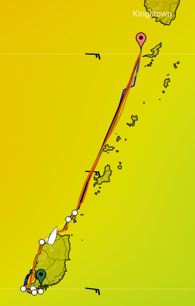
Marie-Claude was not able to join me mid November to come to Grenada and launch Komeekha. She had doctors appointments that could not be changed so she arrives December 5th in St. Vincent instead. At first glance that did not seem impossible with a week to get Komeekha ready for launch and a week and a half to get to St. Vincent. With arranging the fridge repair needing replacement of a major system part and having issues with the dingy motor not wanting to cooperate, plus other issues with things not fully working out as they were expected caused some delays and time constraint. Time felt a bit short with all this plus needing a weather window to travel North North East to St. Vincent. From Grenada to Martinique, these Windward islands are in a North North East line. Waiting for the wind to come from the right direction, South East preferably and of reasonable strength, not blustery like can happen at this time of year can be daunting. With great winds forecasted I solo sailed Wednesday up the western side of the islands from Grenada to Bequia, an island just south of St. Vincent main island. Now this is not a major distance, 76 nautical miles. Sort of like a Wiarton to Killarney run on Georgian Bay, but not quite. Weather can be the same but the waters are not. One, we have to dodge an underwater active volcano called Kick em Jenny when leaving the North West end of Grenada. This takes us either east or a bit west of our intended straight line heading North North East. Standard exclusion zone deviation is a 1 mile radius to stay away from the underwater volcano, like Wednesdays status. If more active, the exclusion zone radius is 5 miles. The Caribbean islands also sit on an underwater ridge separating the Atlantic from the Caribbean sea. First the waters are a lot deeper once no longer over the ridge, more than 10 times deeper than the ridge or Georgian Bay, thousands of feet deep. Add to that the effect of tides that cause quite the currents passing over the underwater ridge portion plus very turbulent waters in the transition zone to the deep waters. My plan was to stay on the western side of the islands in the deep part. When we travel at a speed of 5-7 knots and the current comes at us from the side at 1-2 knots, and sometimes more dependent where one is between the islands, for every hour traveled with a side current, one moves further west or east 1-2 miles each hour. Now this 14.5 hour trip Wednesday, that could have major impact when manually steering. Fortunately all the islands are in sight of each other so visually one can always aim for where they want to go, hopping from one island to the next. With a current this is not a straight line when hand steering, as the current moves the boat to the side, the helms person automatically keeps adjusting aiming direction to the destination target till they get to the intended island. That effect causes travel to the destination in an arc resulting in leaving the perception that the destination was overshot or undershot, all dependent on the side currents direction. So for a trip like this, the routes rhumb line is established from point A to point B on the chart plotter. As the ship deviates to one side of the line, that indicates there is a side current coming from the opposite side. Now a heading compass adjustment can be done to keep us on a straight line and at times dependent on boat speed, could be 10-20 degrees or more aimed away from the rhumb line. This requires constant attention, especially between the islands where the current is greatest. The islands act as blockers and that leads to faster speeds over ground or slower speeds dependent on the direction of the current as it curls around the island. The knot meter in this case is always showing a discrepancy from the radio/plotters GPS speed over ground and the knot meter in the water showing water speed of the sailboat.
So this Grenada to Bequia trip is not as simple as a Wiarton to Killarney run where we have simply aimed the boat and let it drive itself checking up on it every now and then. Not so in the Caribbean. The instruments need constant checking to make sure we are not drifting off course. This is where an autopilot comes in and makes traveling on water so much more relaxing than driving a fast moving car. Hardly touched the steering the entire trip. Simply changed the autopilot degree headings by push button on a regular basis to keep us on track. Sailing in the ocean or Caribbean waters I would say requires an autopilot and chart plotter to give us the real time information needed for a straight line to our destination instead of meandering if we did not have any of this equipment. Was a great day and solo sail.


